


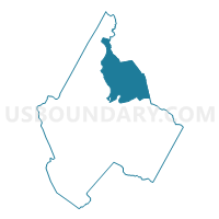
Voting District 02, Avery County, North Carolina
About
Outline

Summary
| Unique Area Identifier | 639305 |
| Name | Voting District 02 |
| County | Avery County |
| State | North Carolina |
| Area (square miles) | 27.77 |
| Land Area (square miles) | 27.75 |
| Water Area (square miles) | 0.02 |
| % of Land Area | 99.92 |
| % of Water Area | 0.08 |
| Latitude of the Internal Point | 36.16133190 |
| Longtitude of the Internal Point | -81.87781400 |
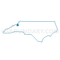
Maps

Graphs
Select a template below for downloading or customizing gragh for Voting District 02, Avery County, North Carolina


Neighbors
Neighoring Voting District (by Name) Neighboring Voting District on the Map
- Voting District 03, Avery County, NC
- Voting District 05, Avery County, NC
- Voting District 08, Avery County, NC
- Voting District 11, Avery County, NC
- Voting District 13, Avery County, NC
- Voting District 14, Avery County, NC
- Voting District 17, Watauga County, NC
- Voting District 19, Watauga County, NC
- Voting District 20, Watauga County, NC
Top 10 Neighboring County Subdivision (by Population) Neighboring County Subdivision on the Map
- Watauga township, Watauga County, NC (3,558)
- Banner Elk township, Avery County, NC (2,996)
- Laurel Creek township, Watauga County, NC (1,947)
- Newland No. 1 township, Avery County, NC (1,189)
- Shawneehaw township, Watauga County, NC (765)
- Montezuma township, Avery County, NC (676)
- Beech Mountain township, Avery County, NC (672)
- Cranberry township, Avery County, NC (614)
- Linville township, Avery County, NC (453)
- Heaton township, Avery County, NC (443)
Top 10 Neighboring Place (by Population) Neighboring Place on the Map
- Banner Elk town, NC (1,028)
- Beech Mountain town, NC (320)
- Sugar Mountain village, NC (198)
- Seven Devils town, NC (192)
Top 10 Neighboring Unified School District (by Population) Neighboring Unified School District on the Map
Top 10 Neighboring State Legislative District Lower Chamber (by Population) Neighboring State Legislative District Lower Chamber on the Map
Top 10 Neighboring State Legislative District Upper Chamber (by Population) Neighboring State Legislative District Upper Chamber on the Map
Top 10 Neighboring 111th Congressional District (by Population) Neighboring 111th Congressional District on the Map
Top 10 Neighboring Census Tract (by Population) Neighboring Census Tract on the Map
- Census Tract 9209, Watauga County, NC (4,404)
- Census Tract 9303.01, Avery County, NC (3,515)
- Census Tract 9301, Avery County, NC (3,100)
- Census Tract 9302, Avery County, NC (2,723)
- Census Tract 9210, Watauga County, NC (387)